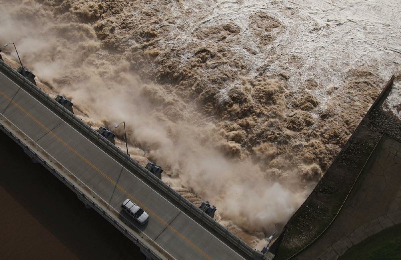
Gov. Asa Hutchinson declared a state of emergency Friday ahead of a rush of water that is predicted to cause historic flooding along the Arkansas River and increase its flow to nearly eight times what is considered dangerous, authorities said.
Crest rates for the river are rising in Arkansas as water creeps closer from Oklahoma, where 6 to 12 inches of rain has fallen in the past week. The National Weather Service said Friday that the anticipated flood level in Van Buren will be 41 feet when it crests Sunday, 3 feet higher than the highest-recorded crest in that area and nearly 5 feet higher than the water has risen in 30 years.
Ozark, Dardanelle, Morrilton, Toad Suck and Pendleton -- along with several communities in between -- are expected to flood higher than they have in 30 years as the water moves southeast over the next week.
Water flows at Trimble Lock and Dam near Fort Smith were at 340,000 cubic feet per second Friday and are expected to peak at 560,000 cubic feet by Monday. A small-craft advisory is issued at 70,000 cubic feet, when the water is considered too dangerous to safely operate a small boat.
"This is quite possibly the most dangerous body of water in North America right now," said Melody Daniel, spokesman for the Arkansas Department of Emergency Management.
Although no counties have issued mandatory evacuations yet, Daniel said many areas have advised evacuation in commonly flooded areas.
"Several counties have already submitted a verbal disaster declaration," she said.
U.S. Army Corps of Engineers spokesman Laurie Driver said she hopes Arkansans are acting now to save their belongings, animals and lives.
"One of our main concerns is making sure everybody up and down the river understands what's coming and that they need to be taking action of some sort now," Driver said. "People need to be deciding what things they don't want to lose. What can you not replace?"
Hutchinson directed the Arkansas National Guard to send two 13-man rescue teams to the western part of the state, where rising river waters have begun to pool in cities like Fort Smith.
Hutchinson said people should heed evacuation orders if they are given and urged them to follow instructions from their local emergency offices as the water makes its way downstream throughout the weekend and next week.
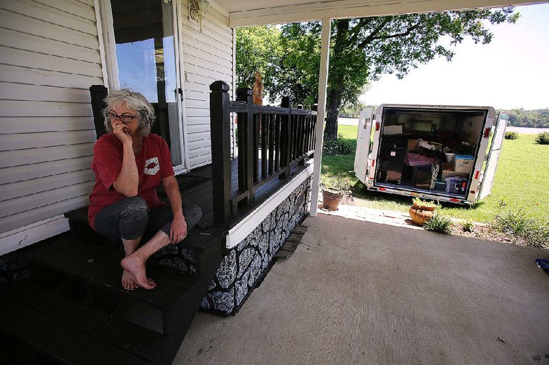
Jan Sloss lives in the Toad Suck community in Perry County and said she doesn't need a formal evacuation notice to know when to leave. Sloss has been able to throw a rock into the Arkansas River from her back door for more than 18 years, and Friday she was hoisting the last of her belongings into a friend's pickup.
"I've lived on the river long enough to know when it's time to go," she said. "They don't have to tell me. I know my marks out here on this river, and I know what's coming."
Normally when her home is at risk of flooding, Sloss said she goes to a friend's home on higher ground not far down the road. This time, her friend is evacuating, too.
"In January 2016, [floodwater] went up and came down quick," Sloss said. "This will not. It's going to rise and then it's going to stay. When the river goes down, my son will bring a camper down where I'll stay until we know whether my house is salvageable, but I don't think it will be."
Arkansas' Red Cross division opened a shelter in Fort Smith on Friday afternoon and said in a statement that it has been in contact with local emergency officials to identify any potential emergencies.
Hutchinson's water rescue teams will be stationed in western Arkansas today and will follow the floodwaters east as more areas experience damage.
Driver said the Corps has been fortifying its infrastructure and placing sandbags around equipment and buildings that are expected to flood.
The Corps operates four of the 44 levee segments in Arkansas. Local levee boards maintain 28 other levees, and Driver said a handful of levees are privately operated.
U.S. Army Corps teams are inspecting their levees and are contacting all locally operated levees to ensure the coordinators know what is coming, Driver said. The Corps built 28 of the 44 levees in existence back in the 1940s and 1950s, Driver said, and their maintenance has been under the care of local levee boards since.
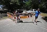
In Fort Smith, where waters are already at flood stage, Sebastian County sheriff's office spokesman Capt. Philip Pevehouse said multiple city parks have closed as well as portions of South 66th Street. He said many creeks in the county will overflow with backwater from the Arkansas River, causing widespread flooding that will likely top several roadways.
"Most of the people who live in those areas know what to do," Pevehouse said. "Our main issue is: What if we have to get somewhere in an emergency?"
The flooding is caused in large part by a torrent of storms that has plagued northeast Oklahoma in recent weeks, National Weather Service meteorologist Brian Smith said.

Driver said the flood reduction lakes in Oklahoma have filled and reached a point where they can no longer safely hold more water without endangering the dams there. As a result, large amounts of water are flowing from those reservoirs into the Arkansas River.
Although a high-pressure system is keeping most storms at bay for Arkansas, Smith said more rain is in store for Oklahoma.
"Unfortunately we are going to see more rainfall in Oklahoma, still several additional inches to come," Smith said. "It's all going to roll this way. It just does not bode well."
Forecasters do not predict major flooding in Little Rock, where the highest-recorded crest was in 1943 at 34.6 feet. The crest from this influx of water is predicted to be 26.5 feet, about 3 feet above flood stage.
North Little Rock planned to close several portions of the Arkansas River Trail, city spokesman Nathan Hamilton said. The Cook's Landing Park parking lot also was set to be closed Friday afternoon in anticipation of the river rising to at least 15½ feet by this morning, which would put the lot partially underwater.
North Little Rock officials said they expected the Arkansas River to rise to 14 or 15 feet Friday, to 17 or 18 feet today, to 19 or 20 feet Sunday and up to 22 feet Monday, Hamilton said.
Little Rock Parks and Recreation Director John Eckart said no park areas on the Little Rock side of the river would be closed during Memorial Day weekend.
Eckart said he will keep in touch with the U.S. Army Corps of Engineers to prepare for when water levels are expected to reach their peak June 1, which might result in some midweek closures.
Sloss, who has evacuated from flood waters before, said she doesn't know if she'll be able to live in her riverside home after this. She'll miss her flowers and the peaceful evenings spent by the water, but she said she understands the risk.
"It sure looks like it's going be worse than they think it'll be," she said before packing the last two boxes of her belongings into a truck headed to high ground.
"It's going to be fine. Whatever happens, I will make myself fine."
Information for this report was contributed by Youssef Rddad and Rachel Herzog of the Arkansas Democrat-Gazette.
A Section on 05/25/2019